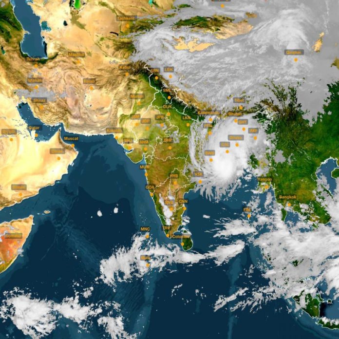
New Delhi (NVI): The cyclone Bulbul intensified into a very severe cyclonic storm triggering heavy rain in parts of Odisha and West Bengal and it was likely to make landfall between West Bengal and Bangladesh in the early hours of Sunday.
The Bulbul will bring in its wake heavy rain and gusts of up to 135 kmph in the coastal areas as the Indian Meteorological Department (IMD) issued an orange alert for coastal areas of West Bengal.
According to IMD, “Cyclone Bulbul intensified into a severe cyclonic storm in the evening (1730 hrs IST on Friday) over west-central and adjoining east-central Bay of Bengal” and the system was moving north-northwestwards over the Bay of Bengal.
Cyclone Bulbul is currently located about 450 km south-southwest of Sagar island in West Bengal and 550 km south-west of Khepupara in neighbouring Bangladesh.
The weatherman said the severe cyclonic storm, which lay centred 600 km south of Kolkata on Friday morning, was expected to intensify further by Saturday and move northwards.
During landfall, ‘Bulbul’ is “very likely” to be in the ‘severe cyclonic storm’ category with a maximum sustained windspeed of 110 to 120 km per hour, gusting up to 135 kmph, Regional Met Director GK Das said in Kolkata.
“The severe cyclonic storm Bulbul is moving at a speed of 13 km/hour in a northward movement. It is presently over the Bay of Bengal and will move north till November 9 and then it will start recalling. It is expected that, by midnight of November 9, it will hit the coast of West Bengal and Bangladesh. It will cross at Sundarban and at the time of crossing its intensity will reduce from ‘very severe cyclonic storm’ to severe cyclonic storm,” informed Ganesh Kumar Das, director, Regional Meteorological Centre in Kolkata.
The cyclone is unlikely to make the landfall in Odisha, but the state will face heavy to very heavy rainfall in its coastal and northern districts in the next two days, Bhubaneswar Meteorological Centre Director HR Biswas said.
Acting on the advice by the weatherman, both states suspended fishing activities from Friday onwards over the West Bengal-Odisha coasts.
The Met department has predicted light to moderate rains in coastal Bengal with isolated heavy rainfall in North and South 24 Parganas and East Medinipur, Howrah and Hooghly districts till Saturday.
Meanwhile, the Eastern Naval Command has kept three IN Ships at Visakhapatnam on standby with relief material to be immediately sent to the most affected areas to undertake Humanitarian Assistance and Disaster Relief (HADR) operation, an official statement said.
Besides, ten diving and medical teams have also been kept ready for augmenting rescue and relief efforts in Odisha and West Bengal. Naval aircrafts are kept ready at Naval Air Station, INS Dega to undertake aerial survey of the most affected areas, casualty evacuation and airdrop of relief material as required. Naval Officers-in-Charge, West Bengal and Odisha are in constant liaison with respective State Administrations for rendering assistance as required.
-nad


