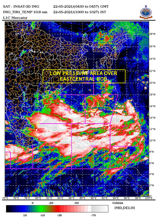
New Delhi (NVI): Low-pressure area has formed over the east-central Bay of Bengal today morning and likely to intensify into a cyclonic storm by May 24, according to the Indian Meteorological Department (IMD).
Alert issued for Odisha and West Bengal coasts as the cyclonic storm over Bay of Bengal are likely to intensify further into very severe cyclonic storm, move north-northwestwards and cross West Bengal and adjoining north Odisha & Bangladesh coasts around May 26 evening.
The fishermen are advised not to venture into southeast Bay of Bengal & south Andaman Sea from May 21 onwards, into central Bay of Bengal from 23– 25 May and into north Bay of Bengal and along & off West Bengal – Odisha – Bangladesh coasts from 24 – 26 May, the IMD said.
Meanwhile, a fresh Western disturbance emerged as a cyclonic circulation lies over north Pakistan & adjoining Jammu & Kashmir at 5.8 km above mean sea level with a trough aloft at 7.6 km above mean sea level roughly along longitude 68°E to the north of latitude 20°N.
Under its influence, thunderstorm and lightning accompanied with scattered rainfall over Western Himalayan Region and isolated rainfall likely over plains of Northwest India during next 24 hours and isolated rainfall over Northwest India during subsequent 24 hours.
Thundersquall with light to moderate intensity rain and gusty winds with speed of 50-70 Km/h would occur over and adjoining areas of entire Delhi, Kotputli, Khairthal, Alwar, Viratnagar (Rajasthan), Gohana, Gannaur, Sonipat, Panipat, Kharkhoda, Rewari, the IMD said.


